Natural Disturbance, Engineered Landscapes, and Community Displacement
By Alycia Hanson, Graduate Research Assistant (2025-2026)
Landscape change is often described through natural disturbance, such as floods and fires, but in many modern contexts it is engineered through large-scale human intervention. Landscapes are best understood as integrated human–environment systems shaped by ecological, social, political, and economic forces, a perspective that highlights how infrastructure projects like dams actively transform both ecosystems and communities. In the Willamette Valley, mid-twentieth-century dam construction by the U.S. Army Corps of Engineers converted dynamic river systems into controlled reservoirs, reducing downstream flood risk while submerging upstream towns, farmlands, and infrastructure. These projects represent a shift from natural to engineered disturbance, where environmental change is dictated by human decision-making rather than ecological processes. As political ecology research suggests, such transformations are inherently uneven, with benefits like flood protection and economic development distributed broadly, while costs fell disproportionately on rural communities in reservoir zones. This pattern reflects global trends, as millions have been displaced by dam construction worldwide, often experiencing long-term social and economic disruption. Beyond material loss, displacement profoundly disrupted residents’ sense of place, severing deep connections to land, memory, and community. Reservoirs have reshaped how these landscapes are remembered, often appearing natural over time and obscuring histories of displacement. Together, these dynamics demonstrate that engineered landscape change produces interconnected ecological and social consequences, reinforcing the need to understand environmental transformation as both a physical and human process.
The Atlas of Drowned Towns already plays an important role in documenting how dam construction reshaped human communities in the Willamette Valley. Through oral histories, archival research, and digital storytelling, the project captures the experiences of displacement, loss, and adaptation among residents whose towns were submerged by reservoirs. These narratives highlight how communities were uprooted, how social networks were disrupted, and how connections to places were fundamentally altered. However, while the Atlas effectively documents human experiences, it primarily presents these changes as social and cultural processes rather than as part of broader environmental transformations. Expanding the project to more explicitly incorporate landscape and ecosystem change would allow for a deeper interpretation of displacement by showing how alterations to rivers, habitats, and ecological systems shaped the conditions that led to these human experiences.
The ecological transformations caused by dam construction also shaped how displaced communities adapted to new environments and rebuilt their lives. Research on social-ecological systems highlights the interconnectedness of human and environmental systems, emphasizing that disturbances in one domain inevitably affect the other. In the Willamette Valley, displaced residents relocated, maintained social ties, and adjusted to new conditions shaped by altered landscapes and ecosystems. However, adaptation does not eliminate the impacts of displacement. Studies consistently show that the loss of place-based identity and cultural continuity can persist across generations, shaping how communities remember and relate to the past. These outcomes underscore that displacement is not only a social process, but also an environmental one, rooted in changes to the landscapes and ecosystems that sustain community life.
In the oral histories we have conducted for this project, we often see how the environment and communities are intertwined. One narrator, Harold, recalled learning to swim in the local river:
But [pause] it was an interesting life when we were kids, there, that – I learned to actually dog-paddle in the North Santiam River… because the older boys threw me in, and says, ‘grab a fistful of water and pull it to you!'
Another community member of the Detroit, Oregon area, Kathy, spoke about how the fire didn’t just take her house, but a lifetime of memories tied to that place:
Everything. I mean, my house went from – we bought that property in 1979 and had lived there ever since, and then the fire came through. And when you live in one place, you know, for so long, I mean, your whole life is right there, you know. So, yeah, we lost everything.
When looking at reshaping an environment, it’s important to consider how it will reshape the communities as well. Research on governance and environmental decision-making also highlights that when affected communities have limited influence over these transformations, the resulting impacts are often more severe and long-lasting.
Digital environmental projects provide important models for understanding how landscape change impacts both ecological and human systems. Platforms such as Global Forest Watch use satellite data to track deforestation and land-use change, demonstrating how alterations to landscapes affect biodiversity, wildlife habitat, and ecosystem function. Similarly, NOAA’s Sea Level Rise Viewer visualizes how environmental transformations alter coastlines, infrastructure, and human settlements, making visible the cascading impacts of environmental change across ecosystems and communities. An example below shows how marshes have migrated over time in Oregon.
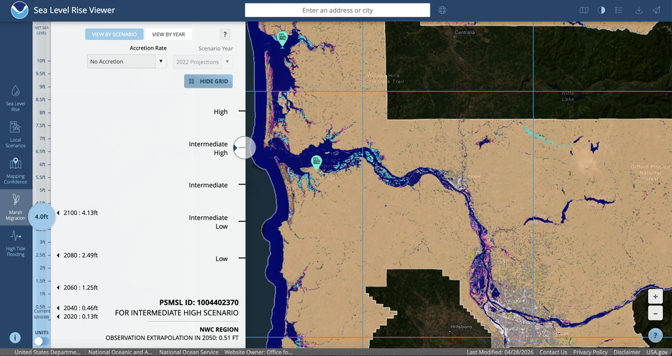
Hydrological tools developed by the U.S. Geological Survey further show how modifying river systems alters flow regimes, sediment transport, and aquatic ecosystems, directly influencing human livelihoods, settlement patterns, and cultural practices. Together, these tools demonstrate that landscape change is not an isolated physical process but one that produces cascading effects across both ecological and social systems, reinforcing the need to understand environmental transformation as a coupled social-ecological process.
Digital projects focused specifically on environmental and climate change further demonstrate how ecological transformation can be visualized in ways that directly connect to human experience. Projects such as Future Coastlines and Climate Central Surging Seas use interactive mapping and elevation data to model how rising water levels reshape coastlines, infrastructure, and ecosystems over time. These tools allow users to visualize changes across multiple scenarios, showing how wetlands, habitats, and developed areas are transformed as water encroaches on land. Below is just one example of how Climate Central’s screening tool can be used to look at how the percent of wetlands can change due to rising sea levels in certain counties in Oregon.
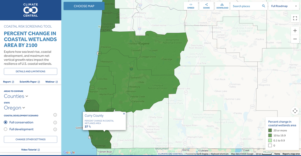
By combining spatial data with projections and visual overlays, these projects make environmental change legible and immediate, illustrating not only physical transformation but also the implications for human settlement and displacement. Similarly, The Changing Arctic documents shifts in climate, wildlife, and ecosystems through maps, visual data, and explanatory storytelling, highlighting how changes in sea ice, species distribution, and habitat conditions affect both nonhuman systems and Indigenous communities. By synthesizing scientific research and presenting it through accessible visual formats, this approach demonstrates how environmental data can be translated into interpretable insights about landscape and ecosystem change. Platforms such as EcoAtlas, a web-based environmental mapping platform, further illustrate how ecological data can be integrated through layered mapping. EcoAtlas compiles multiple datasets, including wetland extent, habitat condition, restoration projects, and monitoring results, into interactive maps that allow users to analyze ecosystems at a landscape scale. By combining these data layers, the platform provides a more comprehensive view of how habitats change over time. This approach could be applied in the Atlas to illustrate how dam construction reshaped river systems, habitats, and ecological processes across the landscape.
These projects demonstrate specific methods for visualizing ecological change over time that could be applied to the Atlas. Interactive mapping and layered visualizations could allow users to compare pre-dam and post-dam landscapes, making visible how rivers, floodplains, and habitats were transformed by reservoir construction. Time-based modeling and scenario visualization could illustrate how ecological systems changed over time, including shifts in water flow, sediment patterns, and wildlife habitat. By incorporating these tools, the Atlas could show that displacement was not only the result of infrastructure development, but also part of a broader transformation of ecological systems that sustained both human and nonhuman communities. This approach would deepen the project’s interpretive framework by linking environmental change directly to lived experience, helping users understand how the loss of homes, livelihoods, and cultural landscapes was intertwined with the alteration of rivers, ecosystems, and habitat.
Another important model for understanding landscape change is the Mannahatta Project, a historical ecology initiative led by the Wildlife Conservation Society. The project reconstructs the ecological landscape of Manhattan as it existed in 1609, prior to large-scale European settlement, using historical maps, ecological data, and geographic information systems. By combining archival research with scientific modeling, the project recreates forests, wetlands, streams, and wildlife habitats that once existed across the island. Researchers estimate that Manhattan supported extensive biodiversity, including hundreds of plant and animal species, as well as complex interconnected ecosystems shaped by both natural processes and Indigenous land management. This approach highlights that landscape change impacts not only human communities but also animal populations and broader ecosystems. By comparing past and present landscapes, the Mannahatta Project demonstrates how urbanization has transformed habitats, altered hydrological systems, and reduced biodiversity. It also emphasizes that human decisions about land use, infrastructure development, and resource management play a central role in shaping these outcomes.
The Atlas is well positioned to build on these approaches. While the project already documents community displacement and memory, integrating a historical ecological perspective, similar to the Mannahatta Project, could further strengthen its interpretive power. Reconstructing what these landscapes looked like before dam construction and comparing them to present conditions would help illustrate how dams transformed river systems, wildlife habitats, and broader landscape processes. For example, in the area surrounding Detroit Lake, the Atlas could map pre-dam river channels, floodplains, and forested habitats alongside current reservoir boundaries to show how the inundation of these environments reshaped both ecological systems and human settlement patterns. Drawing from approaches used in platforms such as Global Forest Watch, the Atlas could also incorporate satellite imagery and historical aerial photographs to allow users to compare past and present landscapes directly, making visible the transformation of rivers, forests, and habitat over time. By combining community narratives with environmental data, such as changes in river flow, habitat loss, and ecosystem dynamics, the Atlas can more clearly demonstrate how engineered landscapes impact both human and nonhuman communities. Tools similar to the NOAA Sea Level Rise Viewer and Climate Central’s Surging Seas could be used to create layered, interactive maps that allow users to toggle between different time periods or explore how specific locations were transformed. Approaches used in EcoAtlas could further support this by integrating datasets such as land use, habitat condition, and hydrological change into a single visual framework. Together, these methods would allow the Atlas not only to document displacement, but also to explain how environmental transformation shaped the conditions that made displacement necessary, ultimately providing a more holistic and interdisciplinary understanding of landscape change.
The lessons from the Willamette Valley point toward several important considerations for future environmental management. First, the concept of disturbance must be expanded to include human-engineered transformations that impact both ecological systems and human communities. Dams do not simply respond to natural variability; they actively alter river systems, habitats, and landscape processes while redistributing risk. Second, displacement should be treated as a central concern rather than a secondary consequence. Addressing displacement requires more than compensation; it demands recognition of cultural, social, and ecological losses. Third, environmental justice must play a central role in infrastructure planning, ensuring that the costs and benefits of development are distributed more equitably across both human populations and the environments they depend on. Finally, documenting and interpreting past cases of displacement is essential not only for informing future decisions, but also for understanding how environmental transformation reshapes interconnected human and ecological systems.
The damming of rivers in the Willamette Valley demonstrates that landscape change is both an environmental and social process, shaped by human decisions and power dynamics. Through the lens of human-landscape interaction and community experience, these projects can be understood not simply as engineering achievements but as transformative events that reshaped ecosystems, habitats, and human lives. For the Atlas, this means expanding its focus from a primarily human-centered narrative to one that also interprets the transformation of the nonhuman world as central to understanding displacement. By incorporating ecological data, spatial visualization, and temporal analysis alongside community narratives, the Atlas can more effectively demonstrate how environmental change shaped both human and nonhuman systems. Drawing from environmental digital projects, the Atlas could better visualize the connections between dam construction, ecological change, and displacement, strengthening its ability to interpret how environmental change shaped human experience. In doing so, the Atlas would realize its potential as an interdisciplinary project that not only documents displacement, but also explains how transformations in the nonhuman world fundamentally reshaped human communities and their relationships to place.
Bibliography
- Climate Central. “Surging Seas: Risk Zone Map.” https://coastal.climatecentral.org/map
- Future Coastlines. https://coastal.climatecentral.org/.
- Global Forest Watch. https://www.globalforestwatch.org/.
- Harden, Carol P., et al. “Understanding Human-Landscape Interactions in the Anthropocene.” 2014.
- International Rivers. “Dams and Development.” https://www.internationalrivers.org/.
- MDPI. “Land Use and Land System Change.” https://www.mdpi.com/2073-445X/12/7/1321.
- National Park Service. “Cultural Landscapes.” https://www.nps.gov/subjects/tellingallamericansstories/.
- NOAA. “Arctic Report Card / The Changing Arctic.” https://arctic.noaa.gov/report-card/.
- NOAA. “Measuring the Human Dimensions of Coastal Ecosystems.” https://coastalscience.noaa.gov/project/measuring-human-dimensions-coastal-ecosystems/.
- NOAA. “Sea Level Rise Viewer.” https://coast.noaa.gov/slr/.
- Oregon Encyclopedia. https://www.oregonencyclopedia.org/.
- San Francisco Estuary Institute, “EcoAtlas,” https://www.ecoatlas.org/.
- ScienceDirect. Environmental displacement article. https://www.sciencedirect.com/science/article/pii/S0301479709001583.
- U.S. Army Corps of Engineers. “Willamette Valley Project.” https://www.nwp.usace.army.mil/Missions/Projects/Willamette-Valley/.
- U.S. Geological Survey. Water Data. https://waterdata.usgs.gov/.
- Wildlife Conservation Society. “The Mannahatta Project.” https://newsroom.wcs.org/News-Releases/articleType/ArticleView/articleId/6032/WCS-Launches-Mannahatta-Project.aspx
- World Commission on Dams. Dams and Development: A New Framework for Decision-Making. London: Earthscan, 2000. https://www.internationalrivers.org/wp-content/uploads/sites/86/2022/06/world_commission_on_dams_final_report.pdf.